Local Winds of the Pacific and Inland Northwest
The strongest large-scale winds that influence the Northwest are associated with large-scale weather systems that feature both strong surface pressure gradients and a jet stream aloft. On localized scales, smaller scale pressure differences associated with contrasts between water and land, and interactions of upper-level winds with topography can result in local winds.
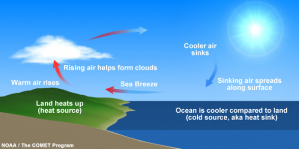
The stronger heating of the land surface compared the the ocean surface during the daytime results in less dense and buoyant air over land and the development of a thermal low pressure. Cooler air over the ocean moves inland due to the pressure gradient force thus providing that nice onshore flow to cool things off near the immediate coast.
Onshore flow may often increase the ambient moisture of the airmass and enhance afternoon convection leading to clouds forming over the heated airmass.
What do you think happens at night to this circulation?
Onshore flow may often increase the ambient moisture of the airmass and enhance afternoon convection leading to clouds forming over the heated airmass.
What do you think happens at night to this circulation?
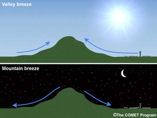
The ground warms and cools faster than the overlying air. This is why you might observed frost on the ground even though the official temperature did not drop below freezing. During the overnight hours the air near the ground cools rapidly. As cold, dense air will tend to migrate downhill following gravity. In mountainous areas, air cooling on a mountain peak will flow down the mountain and into the valley's. Often valley temperatures at night are far colder than at higher elevations.
By contrast, during the daytime hours, warm air near the surface will want to rise through convective motion. Unlike air rising on a flat surface, the rising motion at mountain crests is accentuated and results in a surface low pressure that draws warmer air from the valley upslope. Mountain-valley winds are most noticeable during the summer months when large-scale pressure gradients are absent.
An alternative way of thinking about mountain valley breezes is to consider how the surface temperature over a mountain peak varies throughout the day versus air at the same pressure, but not located 2-m above the surface, instead in the free atmosphere. The temperature of the free atmosphere varies little throughout the day in contrast to air over the land surface. Daytime heating forces air over the land surface to be buoyant thereby creating a surface low pressure that forces air toward it. Conversely, cooling temperatures at night forces the air to be more dense
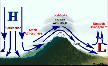
Strong winds often develop in the leeward side of a mountain range. This typically happens when there is a strong pressure gradient across the mountain barrier, and often strongest when coupled with strong winds unrelated to the surface pressure gradient at upper levels of the atmosphere. As air descends a mountain range it undergoes compressional heating. Flow that passes through mountain gaps can be especially potent due to the funneling of air (also called the Bernoulli effect). Downslope winds are very frequent on the east side of the Cascades during summer due to the semi-permanent high pressure over the Pacific and low pressure over the interior. Downslope winds pose significant fire weather threats across much of the western United States, particularly when the surface high pressure originates over a very dry region.
